Lab 05, LiDAR vegetation metrics modeling
Background and Goals:
The main goal of this lab was to gain an understanding of how to extract forest metrics from LiDAR point cloud data. This was achieved through data extraction(namely canopy height) from LiDAR data through LP360, then processing said data with ArcPro.
Methods:
To begin this lab, we extracted vegetation height and ground elevation from LiDAR point data. This was done using the LP360 software. Using those two rasters the canopy height was then calculated, as seen below.

Canopy Height Raster
From there, we then had to calculate the ABG. To achieve this, first we took a land use map of the area, and re-classed it so it has our areas of interest only. That reclassed raster was then used to create a mask in the below model.
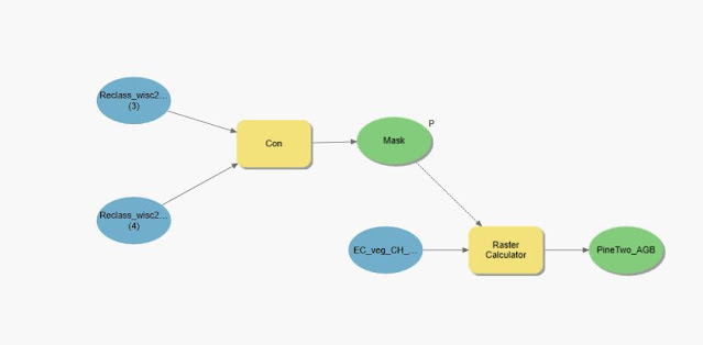
AGB calculation model
The below constants and equation were used to in the final calculate raster step.

Constants and equation to find AGB
The model was then ran for all 5 different types vegetation.
Results:
The result can be seen in the map below.

AGB of Eau Claire
I believe that there was an issue in calculating the AGB of the pine tree stands. I believe the issue stems from an issue with either the conversion of multiple variables, or the actual order of operations with the calculation.
Sources:
Eau Claire County. (2013).[ LAS, Tile Index, Metadata of Eau Claire County]. Eau Claire County. Provided by Cyril Wilson.
United States Department of Agriculture (USDA). (2013).[NAIP imagry]. Geospatial Data Gateway. Provided by Cyril Wilson.
Wisconsin Department of Natural Resources.(2016.)[Land Use data]. Wisconsin Department of Natural Resources. Provided by Cyril Wilson.
Comments
Post a Comment